
A University of Pittsburgh economist who specializes in analyzing the financial risk of climate impacts is working on calculating the value of microgrids to help provide immediate adaptation to climate change as well as long-term mitigation of climate impacts. Dr. Katrina Kelly-Pitou, who has a background in economics and energy engineering, is working with her students at the Swanson School of Engineering at the University of Pittsburgh to analyze which parts of the city are most vulnerable to climate risks. She then uses HOMER Pro to calculate the costs of developing microgrid infrastructure in high-priority neighborhoods, and performs an overall cost-benefit analysis. Originally working with the Department of Homeland Security on data collection, she hopes to expand this work into other cities to identify infrastructure that is most threatened by climate change, thereby helping to solve the gap of “the cost of resilience.”

It’s no easy task to quantify the value of resilience – this factor remains elusive for most corporations that are trying to calculate the benefits of investing in microgrids. While companies can at least start by determining the financial impact of power losses and production downtime from one day to the next, it’s far more complicated to measure the economic and social impact of climate risk to an entire neighborhood or city district. Dr. Kelly-Pitou takes that task one step further in a large, complex city, analyzing multiple neighborhoods to compare the value that microgrids could provide in sustaining vital services during an extreme weather event or other disaster. Dr. Kelly-Pitou’s intent is to provide solid logic and data-driven analysis for city planners to decide which neighborhoods should benefit from microgrid investments, how they would serve the rest of the city during an emergency, and furthermore, how these microgrids could also contribute to mitigation of climate change over the long term. Ultimately she hopes her research will contribute to a “resilient city roadmap” for Pittsburgh, and help city officials decide how to plan for new electrical infrastructure that will have both short and long-term benefits.
Making Cities “Smarter” by Understanding Neighborhood Climate Risk
In one project, Kelly-Pitou and her students worked with the Department of Homeland Security to identify “shocks” and “stresses” to different parts of Pittsburgh. They divided the city into census tracts, which are neighborhoods with populations that range from 2,500 to 8,000 people, identified by the U.S. Bureau of Census, and analyzed different impacts on each neighborhood. The shocks include climate events that are likely to occur such as flooding, extreme temperatures and winter storms, as well as the infrastructure breakdowns that could result, such as transportation failures, water shortages and power outages. The team also identified potential downstream consequences of these events such as hazardous material releases, landslides and fatal mortalities. Climate-related events have already produced many of these outcomes worldwide, ranging from the chemical fires that broke out in Houston after hurricane Harvey, deadly mudslides that followed multiple California wildfires, or the fact that over 14,000 people – mostly elderly – died in a 2003 heatwave in France. All of these impacts need to be considered in a cost-benefit analysis that compares the economic consequences of climate change with the cost of measures that can enable adaptation or mitigate climate change itself.
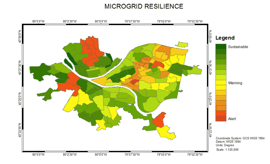
In addition to specific “shocks” that could impact the city, Kelly-Pitou’s analysis incorporated various “stresses” that could exacerbate the financial consequences of climate-related events. These stresses include aged infrastructure, economic and racial inequality, environmental degradation, food insecurity and lack of affordable housing. Combining all these factors, her team produced maps of Pittsburgh that identified which neighborhoods were most sustainable and which warranted resilience “warnings.” Finally, the team factored in data on current carbon emissions, flooding and power outages. Overlaying this data on the sustainability of various census tracts, they created a heat map that shows geographically specific climate vulnerabilities, areas of critical weakness in the city’s resilience. Interestingly, the districts that are most vulnerable to flooding in Pittsburgh are also the neighborhoods that have the highest carbon emissions and most frequent power outages. That, according to Dr. Kelly-Pitou, could point to places where hybrid renewable energy microgrids might be appropriate for short-term adaptation to climate risk as well as long-term mitigation of climate change.
Determining Best Microgrid Locations for Urban Resiliency
Along with the vulnerability of certain districts, Kelly-Pitou says that city planners need to consider increasing the resilience of city services that are critical during emergencies, targeting “safe havens” for hospitals, shelters, and operational headquarters for first responders. The team found that the ideal way to improve resilience is to create a multi-user community microgrid that provides reliable electrical power, where cost can be shared by critical infrastructure users such as local government, medical facilities, cellular networks and water utilities. The ideal emergency microgrid would also support cellular communications reconfigured into a mesh network and local edge computing resources (as opposed to having to rely on the cloud for critical computing needs). Kelly-Pitou says that the longer term value of increasing renewable power generation – enabled by microgrids – should also be factored into the cost benefit equation.
The tricky part is identifying where these microgrids should be located. Using spatial analysis techniques to determine the resilience “importance” of a given area, Kelly-Pitou’s team worked with Abdulaziz S Alqahtani, Dr. David Tipper’s PhD student in telecommunications, to apply “graph network theory” to identify the highest concentrations of Pittsburgh’s critical infrastructure facilities. The results showed where microgrids were most needed in order to improve resilience, and what their overall power requirements were.
Kelly-Pitou used HOMER Pro as a key input, to provide an objective cost analysis for microgrids. Her team calculated the optimal size (approximately 4 MW was required in each case) and configuration of a hybrid renewable energy microgrid for each of the high priority areas, to determine the total net present cost (or life cycle cost) of the projects. Another important factor was the real estate value of the land where the microgrid was located. Kelly-Pitou’s results consistently identified one geographical area of Pittsburgh as the best location for a microgrid that would improve the city’s resilience in the event of a climate-related emergency. She also believes that microgrids provide critical value in moving our energy infrastructure in the direction of sustainability, by mitigating climate change impacts through their use of renewable energy. Kelly-Pitou hopes that her findings will help planners in Pittsburgh and other cities use data-driven methods and modeling to develop better resilience road maps, and advance our preparation for climate-related emergencies.
Resources
Alqahtani, Abdulaziz & Tipper, David & Kelly-Pitou, Katrina. (2018). Locating Microgrids to Improve Smart City Resilience. 10.1109/RWEEK.2018.8473464.
Haven’t tried HOMER Pro yet? Download the HOMER Pro software and try it full-featured and free for twenty-one days.