
The HOMER software is designed for maximum flexibility so that users can either use sample and generic data or add their own datasets and produce highly customized and accurate modeling results. It’s possible to import data sets on wind speed, solar radiation, and load profiles in a number of different formats, including Green Button and Utility API data formats – just to mention a few.
In this tip, we will be talking about finding and importing wind speed data into HOMER.
Many countries have published wind atlases, and there are other organizations that provide wind speed data. Depending upon which product you are using, please visit the user manual to learn more in Finding Data to Run HOMER:
HOMER Pro:
Finding data to run HOMER Pro
HOMER Grid:
Finding data to run HOMER Grid
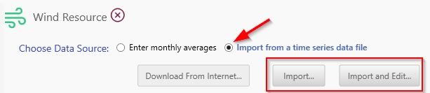
You can also read about how to define the Wind Resource correctly in the HOMER software by visiting the respective Wind Resource page (see below). There you will learn about important parameters for your wind resource (such as setting the hub height), how to create baseline wind data and how to import Wind Speed Data files. You will also understand how HOMER handles time series data files for wind speed.
HOMER Pro:
Wind Resource page (Pro)
HOMER Grid:
Wind Resource page (Grid)
Now that HOMER Energy is a part of UL, we are fortunate to be able to integrate UL’s high resolution wind resource data in our projects. Below we explain how you can use these data sets to enhance your modeling results when you use the HOMER software:
Accessing Windnavigator data from UL
The Typical Year Virtual Met Mast (TY-VMM) data is useful for making an informed decision about the quality of the wind resource at a user specified geographical location.
This statistically representative annual time series of hourly data, typical yearly extremes of wind speed and other provided variables, provides users with a quantitative description of conditions to be expected at a specified site and elevation. The TY-VMM also provides information regarding the diurnal and seasonal variation of the wind speed and direction, important for matching daily and seasonal peak load and demand with wind power production.
Finally, the TY-VMM output includes other variables such as temperature, air density, and energy output. These are critical not only for determining ambient operating conditions for wind energy site assessments, but are also crucial for other industries that require accurate depictions of hourly climate, such as, but not limited to, utility transmission, building and construction, and agricultural production.
The TY-VMM covers a 200 m grid and is delivered in .CSV format. The dataset includes hourly and annual mean wind speed values, date, time, temperature, pressure, direction, air density, turbulence intensity and standard deviation at three user-specified heights.
You can purchase a TY-VMM through Windnavigator, an online dashboard designed to support preliminary stages of wind project development. Platform subscribers have access to mean annual wind speed values, resource characteristics, wind speed maps and data layers. Anyone can create a free account to purchase historical and long-term data sets (time series), and other tools such as preliminary wind resource and energy assessment reports.
Here’s how to get your Windnavigator file to import into the HOMER sotfware:
- Visit the Windnavigator access page >>
- Click on the Time Series icon >>
- Visit the pricing page, select your country / region, and if available view the “Time Series Data” product to understand your pricing options. (if the data is not available in your region, you may have to contact a sales representative) >>
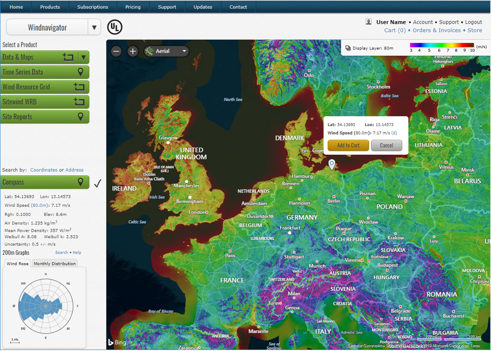
4. Click on the “Purchase” button
5. Create a free account (you will prompted when you click on “Purchase”)
6. View the international wind map (see screenshot above) and navigate to your location or enter the correct coordinates for your project
7. An “add to cart button” will pop up over the map, and you will be able to purchase data for that particular location
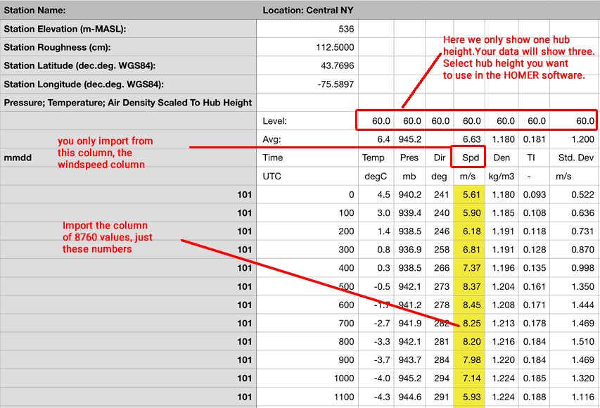
When you purchase a (non-subscription) Windnavigator data file, you can choose to see data for three different hub heights in your file. Remember to select your chosen hub height in HOMER when you are defining your Wind Resource. On the screenshot above, we are just seeing one hub height. The yellow column, for the 8760 wind speed data, is the ONLY data that you will import into the HOMER software. Happy modeling!
If you require an invoice for your purchase, please email Ben Blanchette for help in purchasing your Windnavigator file.